top of page
Historic Textile Mill Sites
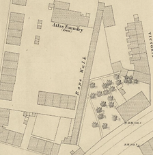
Rope Walk – Brooks Mouth
Town :
Bury
Area :
BL8
Street (on map) :
Brooks Mouth
Street (today) :
Waterloo Street
Latitude :
53°35'39.98"N
Longitude :
2°18'35.64"W
Type :
Ropes
Site Size (approx.) :
12m x 72m
Reproduced with the permission of the National Library of Scotland
Bury Sheet 3 1847
Notes :

Historic Textile Mill sites
bottom of page